

Places to Birdwatch in the BCAS Area
The Black Canyon Audubon Society area covers many counties in Southwestern Colorado with numerous wonderful places to birdwatch. We would like to share that information with our members and visitors to our area. Keep your eyes on this space as we add places where we enjoy birdwatching in our area!
Delta County
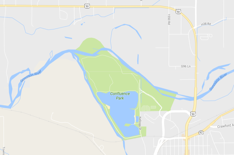
Confluence Park, Delta
Managed by: Delta County
Location: City of Delta along the Gunnison and Uncompahgre Rivers
Directions: From Delta drive north on US 50 past City Market. Turn left at the light on Confluence Drive and continue to first traffic light. Turn right onto N. Palmer St. and take the first left onto Gunnison River Dr. You will come to a ‘T’ at Kellogg St. and can turn either direction to find parking. To the right, you can access the Gunnison River and hiking trails. To the left, you can park at various locations along the reservoir and access hiking trails at the end of the road on the west side of the reservoir.
Accessibility: All access streets are paved. Some parking areas are paved, some are gravel. All paths are gravel or dirt. There are ~5 miles of interconnecting paths through various habitat types.
Habitat type: Woodland, meadow, riparian, and wetland
Birds you might see: A wide variety including herons, ducks, geese, songbirds, raptors, quail, and owls; 203 species of birds have been observed. During late fall and winter, a large number of geese and ducks arrive, including Snow, Ross’, Cackling, and, occasionally, White-fronted in the company of thousands of Canada geese. Barrow’s goldeneye are on the river during the winter and sometimes a few make it onto the reservoir along with a wide number of other waterfowl. Sandhill cranes are often seen in migration, as do Franklin’s and Bonaparte’s gulls in the spring. A few Clark’s grebes can also be expected mixing with the Western grebes in the summer months.
Best time of year: Visit year around to see different types of birds in different seasons.
More Information: deltacountycolorado.com. There are also descriptions at deltacountyindependent.com, traveladvisor.com, and deltacountyliving.com.
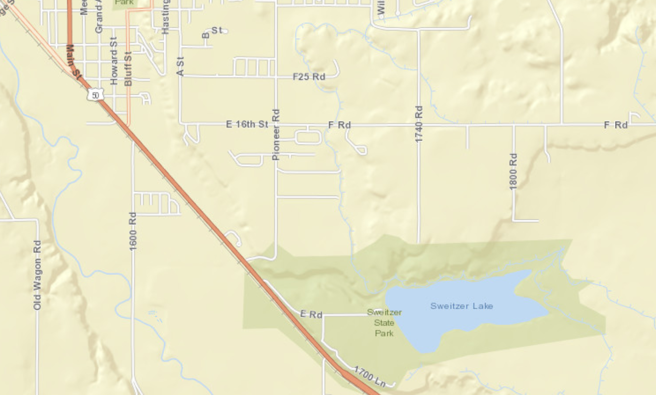
Sweitzer Lake State Park, Delta
Management: Colorado Parks and Wildlife
Directions: From Montrose, travel 19 miles north on US Highway 50 towards Delta. As you approach Delta, watch for a large brown sign indicating the entrance to the park. Turn right where indicated onto Road E. This will take you into the park. From Delta, drive south on US Highway 50 about one mile. Watch for a large brown sign indicating the entrance to the park. Turn left where indicated onto Road E. This will take you into the park.
Accessibility: An entrance fee is collected year round. Either pay at entrance station or purchase or possess a current Colorado State Parks Pass. The main parking lot is paved and public toilets are available. Follow the road that skirts around the south side of the lake. This road is not paved. Road is inaccessible when wet due to heavy clay soils.
Habitat: Primarily salt desert scrub with large mature deciduous and coniferous trees at the entrance and near the parking lot and scattered brush throughout park. Wet alkali mud and riparian plants exist along the southern edge of the lake, including cattails and reeds.
Birds you might see: Birds can be seen all year because the lake rarely freezes completely. Recreational use of the lake (reservoir) is quite heavy in the summer, which tends to scare off birds. Migratory song birds, however, can probably still be seen in the larger trees or along the boundary fence. During the rest of the year, a variety of shorebirds, ducks, wading birds, grebes, and gulls can be seen, as well as an occasional loon, pelican, and cormorant. Waterfowl hunting is allowed during the fall and winter on weekends, Wednesdays, and legal holidays. Birds of prey are always a possibility, including hawks, osprey eagles, accipiters, and falcons. Sweitzer Lake is an eBird hotspot with over 160 species recorded.
Best time of the year: Fall and spring are usually best to avoid summer recreational use and waterfowl hunting season, though it is well worth a stop any time of the year.
Additional information: http://cpw.state.co.us/placestogo/parks/SweitzerLake
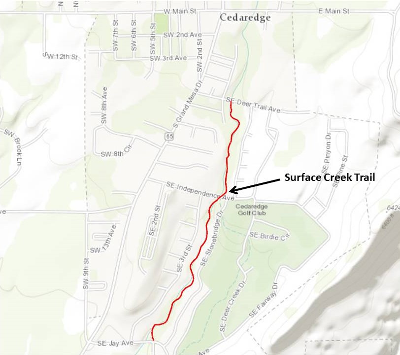
Surface Creek Walking Trail, Cedaredge, Delta County
Managed by: Town of Cedaredge
Location: Southeast side of the town of Cedaredge ~ ½ mile east of Hwy 65
Directions: From Delta take Hwy 92 east to Hwy 65. Travel ~ 10 miles north to Cedaredge. There are three access points – SE Jay Ave., SE Independence Ave., and SE Deer Trail Ave.
Accessibility: All access points are paved roads. Limited roadside parking. The trail is an improved dirt trail just over a mile long one way.
Habitat type: Wooded riparian and rural residential along the eastern side of Surface Creek.
Birds you might see: Mostly songbirds
Best time of year: Probably best spring and summer, but good all year.
More information: n/a
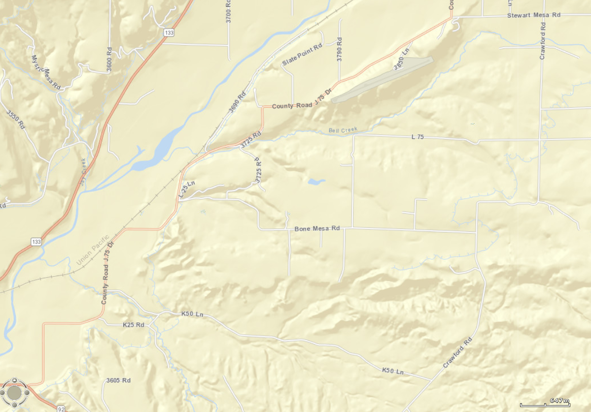
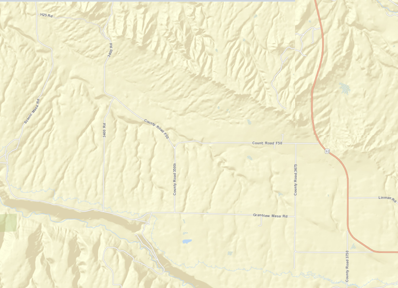
Winter Raptors in Delta County
Where: Public roads in the county between the towns of Paonia,Hotchkiss, and Crawford, and east of the North Fork of the Gunnison River
Directions: Northern Loop: From Hotchkiss, turn east on Highway 92. Cross the North Fork, proceed less than a mile, then turn north on Back River Road. The entire valley floor between the (roughly parallel) Back River Road and Crawford Road, from Hotchkiss to Paonia to Crawford, including the connector roads like Bone Mesa Road and L75 Road, offer great birding for raptors. Scan the fields and road sides for hawks. Look for eagles feeding on road kill, perched in cottonwoods and utility poles, and along the North Fork River.
Directions, Southern Loop: From Hotchkiss, turn east on Highway 92. Cross the North Fork, and continue toward Crawford. After about five miles, turn right onto F50 Road (which eventually turns into 3400 Road). The road travels the lower portion of Grandview Mesa and eventually winds back down to the town of Hotchkiss. While traveling F50 Road, turn left (south) onto 3675 Rd, which leads to Grandview Mesa Road. Turn right (west) and follow this onto Scenic Mesa (the road becomes Scenic Mesa Road) and along the edge of Smith Fork Canyon, or turn north (right) onto 3500 Road or 3400 Road back to F50 Road. The mesas here, south of Hotchkiss and west of Highway 92, including Fruitland Mesa, Grandview Mesa, and Scenic Mesa, offer great winter raptor spotting. Watch for large great-horned owl nests in cottonwoods, and look for harriers hunting in low swales along water courses.
Accessibility: County roads are paved and gravel.
Habitat type: Irrigated meadow, sagebrush, rabbitbrush, adobe badlands, pinon pine-Utah juniper woodlands, bisected by irrigation ditches, and washes.
Birds you might see: Golden eagles, Bald eagles, red-tailed hawks, ferruginous hawks, sharp-shinned and Cooper's hawks, northern goshawks, prairie falcons, merlins, kestrels, great-horned owls, northern harriers, shrikes, and additional winter residents like bluebirds, pheasants, blackbirds, and ducks in the river.
Best time of year: December 1 to March 1.
More information: Be respectful of other travelers on all roads. Pull off the roadway as far as possible when stopping, so as not to impede other vehicles. When out of the vehicle stay within the road right-of-way. Do not cross onto private land.
North Loop Area
South Loop Area
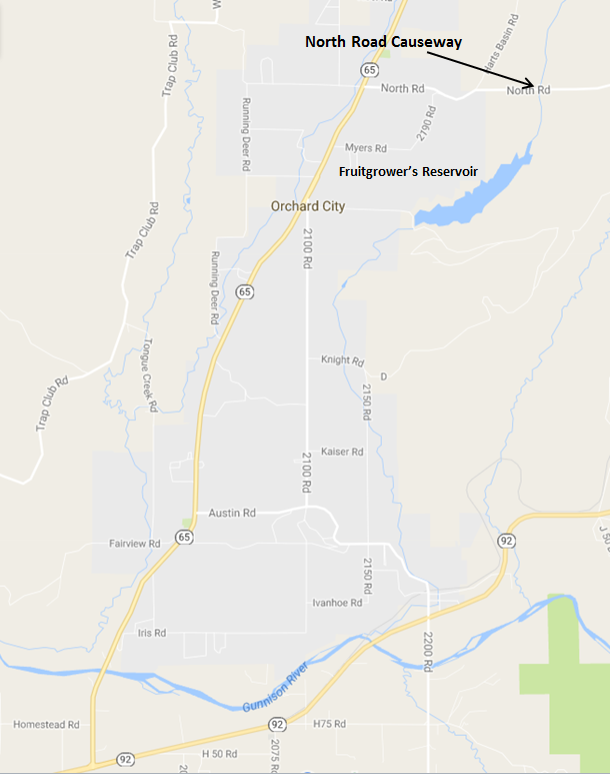
Fruitgrower's Reservoir (also known as Hart’s Basin): North Road (Causeway), Eckert, Delta County
Management: U.S. Bureau of Reclamation; no watercraft are allowed on the reservoir. Private land surrounds BOR land.
Location: The reservoir is approximately 1.1 miles east of the town of Eckert. The main reservoir is on the southern side of North Road (also called N Road) causeway, but during high water, standing water and lush riparian habitat is on the northern side of the causeway.
Directions: From Delta, drive 4 miles east on Highway 92, then turn north on Highway 65 and drive 6 miles to Eckert. Turn right on North Road at Big E Market, which is across from the Eckert Presbyterian Church (large stone church), and proceed east on North Road.
Accessibility: North Road consists of two-lanes and has a few wide areas on the shoulders where it is safe to park. A large parking area is on the western end of the causeway that provides convenient parking from where you can walk along the causeway or access the western shore of the reservoir. The best viewing is from the causeway. Walking along the western shoreline may cause disturbance to birds. Expect to bird from your car or by carefully walking along the road shoulder. Although traffic volume would be considered low, be aware of rural truck and passenger car traffic. Informational signs are at a large pullout, known locally as Crane Point, on the southern side of the road before you drop down to the reservoir that overlooks farmland. This is on private land, so do not wander far, but this can be a good area to see migrating cranes in the fields below, and dryland bird species may be present as well. Other informational signs are along the causeway.
Habitat type: The reservoir is bordered by wetlands/riparian areas with scattered trees.
Birds you might see: all varieties of ducks, grebes (including nesting Clark’s grebes), coots; American white pelican, great blue heron; white-faced ibis; double-crested cormorants; terns and gulls; shorebirds include dowitchers, killdeer, lesser and greater yellowlegs, and other migrating rarities; flycatchers; yellow-headed blackbirds; bald and golden eagles; Bullocks orioles; sora; American bittern; warblers; and western kingbird. Sandhill cranes migrate through the area and overnight near the reservoir during March. EBird data show records for 162 species that have been recorded at this location.
Best time of year to visit: March through August. By the end of September, the reservoir has been drawn down and bird populations are too far out to identify without a scope (and difficult even with one).
More information: Fruitgrower’s Reservoir is recognized as an Important Bird Area of statewide significance by the National Audubon Society. It is also a hotspot on eBird; to find current and annual observations, go to: www.ebird.com Explore Data, click on “Explore Hotspots” and enter Fruitgrower’s Reservoir, North Road Causeway, Delta CO.
Comments: There are no rest rooms along the causeway or at the parking area. Travel from the east to west end of the causeway is approximately 0.7 mile. Most waterfowl stay close to shore and are readily identifiable using binoculars, though a spotting scope is of great assistance.
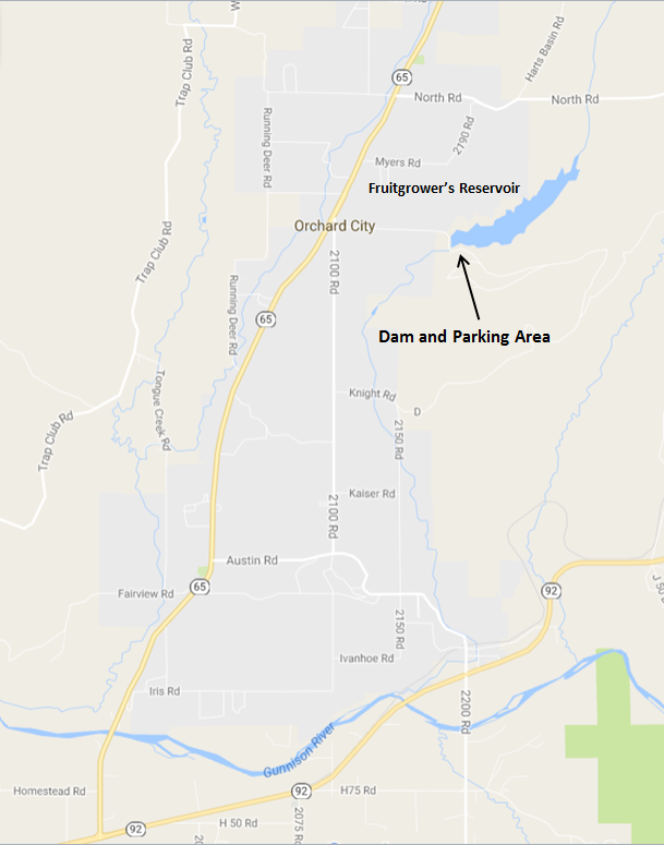
Fruitgrower's Reservoir (Dam Area), Eckert, Delta County
Management: U.S. Bureau of Reclamation. Private land adjacent.
Location: The dam and a parking area with a short paved trail on the southern side of Fruitgrower’s Reservoir is 1 mile east of Highway 65 at Orchard City, about 1 mile south of the town of Eckert. See map below.
Directions: From Delta, drive 4 miles east on Highway 92, then turn north on Highway 65 for 5.2 miles. Turn south on County Road 2100 on the eastern side of the highway. Almost immediately (after about 350 ft.) turn left (east) on Fruitgrowers Road (County Road M); there is a sign for Antelope Hill. Follow Fruitgrowers Road for about 1 mile to the dam. To reach the parking area and trail, continue across the dam and continue eastward for about 1,000 ft., taking the left fork onto a dirt road leading to the parking area near the edge of the reservoir.
Accessibility: The roads to the parking area are paved. There is a handicap-accessible walkway approximately 850-feet long that follows the reservoir and ends in a small viewing turnout. Viewing is from the parking area and along the walk-way.
Habitat type: Across the reservoir is a forested area with mature trees. Formerly present was a great blue heron rookery and double-crested cormorant nesting area. These have not been used for several years. Below the parking area, are scattered trees and shrubs.
Birds you might see: Many varieties of ducks, grebes, coots; great blue herons; belted kingfisher; double-crested cormorants; western kingbird, red-tailed hawk, red-wing blackbirds, doves, and magpies. Ebird has records for 193 species at this location. However, caution, some people mistakenly use this site to record for both the dam and reservoir along North Road, which is accessed through Eckert. See separate description.
Best time of year to visit: March through November. By the end of September, the reservoir has been drawn down but from the dam you can walk along the reservoir shoreline as far as you wish – it is rocky and uneven terrain, wear suitable hiking or walking shoes.
More information: This is a hotspot on eBird; to find current and annual observations, go to: www.ebird.com, select “Explore Data,” select “Explore Hotspots,” and enter Fruitgrower’s Reservoir, Delta, CO.
Comments: Fruitgrower’s Reservoir is recognized as an Important Bird Area of statewide significance by the National Audubon Society. As compared to viewing along the North Road causeway on the northern end of the reservoir, this location typically has fewer species present during the summer; it is best visited in conjunction with a visit to the northern end of the reservoir outside of Eckert. In the fall, when the reservoir has receded and birds cannot be identified without a scope, walking along the exposed shoreline by the dam offers potential sightings.
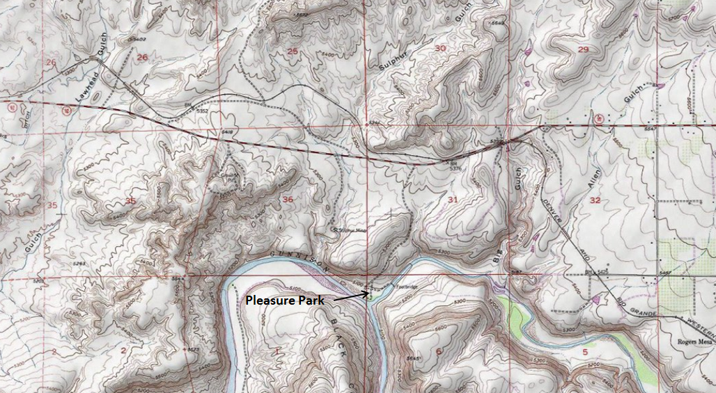
Pleasure Park at the Confluence of the North Fork of the Gunnison and Gunnison Rivers, Delta County
Management: Bureau of Land Management
Location: From Delta: Drive east on Hwy 92 approximately 14 miles to Pleasure Park Rd. There is a BLM sign. Turn right and drive early a mile to end of road where there is a small graveled parking area. From Hotchkiss: Drive toward Delta west on Hwy 92 approximately 5 miles to Pleasure Park Rd.
Accessibility: Road is paved nearly to parking area, accessible to all cars. If conditions are very wet, spur roads from the parking area may be slippery, depending on when gravel was last applied. Look for a rough trail through the willows along the river heading upstream. There are no services but there is a privately owned public business establishment, Gunnison River Pleasure Park, to the west. They sell fishing gear and refreshments.
Habitat: Riparian, Wooded/brushy riparian, high desert in the hills.
Birds you might see: Waterfowl, riparian songbirds, wading birds, raptors, and chukar.
Best time of year: Spring migration, though it’s good year round.
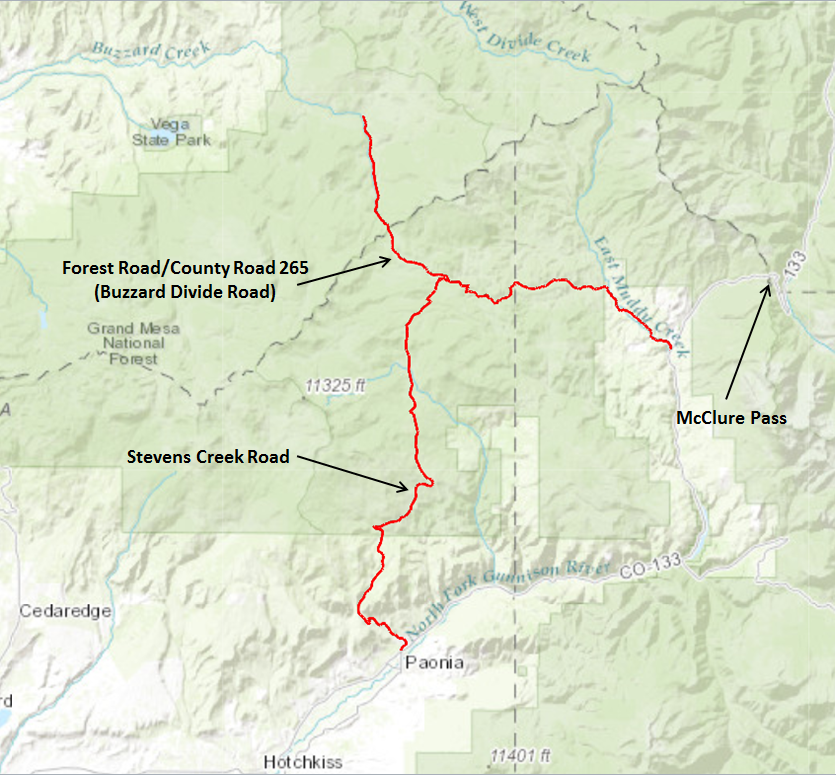
Aspen Habitat – Stevens Gulch/Mule Park/Buzzard-Muddy Creek Divide, Delta and Gunnison Counties
Managed by: Grand Mesa, Uncompahgre, and Gunnison National Forest
Location: North of Paonia
Directions: From Hwy 133 in Paonia, go north on Stevens Gulch Rd (opposite Hwy 187 at the east access to Paonia from Hwy 133) until you hit aspens at the forest boundary. Continue northerly, with Hubbard Park being an often worthwhile stop. Continue until you hit FR 265. (This intersection is about 17 miles north of the intersection of Hwy 133 and Stevens Gulch Rd, where we started, as the crow flies, but much more than that on the odometer.) Turning right/east here takes you through nice aspen habitat, and back to Hwy 133, southwest of McClure Pass. Turning left/west at the junction of Stevens Gulch Rd and FR 265, takes you to excellent pure aspen/open park habitat in Mule Park, over Buzzard-Muddy Divide, and down Buzzard Creek to Silt or Collbran.
Accessibility: Gravel roads, closed in winter, can be treacherous November through early May. High clearance is preferable, but 2WD cars can handle the main roads in summer.
Habitat type: Pure or climax aspen. Also aspen/conifer mix, spruce/fir, mid elevation riparian, and open parkland. The edges of the aspens and open parks are the most unique areas here, especially for birds such as purple martins that hunt in open country, but live in aspen cavities.
Birds you might see: Aspen cavity nesters, including western purple martin, violet-green and tree swallows, mountain bluebird, house wren, northern flicker, red-naped sapsucker, downy, and hairy woodpecker. Also western wood-pewee, and warbling vireo. Spruce-fir birds include gray jay, red crossbill, ruby-crowned kinglet, yellow-rumped warbler, hermit thrush and three-toed woodpecker. Swainson's hawk is possible in aspen-ringed parks, and red-tailed hawk and American kestrel are very common. Peregrine falcon and northern goshawk breed here but are less common. Willow flycatcher, cedar waxwing and fox sparrow are in some riparian areas, along with more common Lincoln’s, song, and white-crowned sparrow, and yellow warbler. Also numerous flammulated, northern saw-whet and boreal owls can be heard at night during breeding season.
Best time of year: Late May through late July is best for most migratory species such as purple martins. Mid July is great for viewing martins and other species feeding young. Mid to late May is good for owls.
More information: N/A
Gunnison County
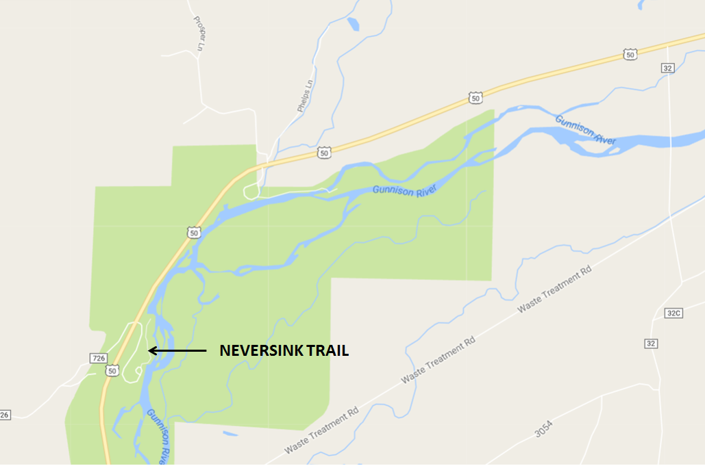
Neversink Trail, Gunnison County
Managed by: Curecanti National Recreation Area, National Parks Service
Location: 5.7 miles west of Gunnison, or 58.9 miles east from Montrose, on the south side of Highway 50
Directions: From Gunnison, take Highway 50 west towards Montrose. Once out of town, turn left (south) into the Neversink trailhead access. If you reach the first bridge on Blue Mesa (Highway 149), you have gone too far! If you are approaching from Montrose, the Neversink turn will be on your right almost immediately after getting out of the Gunnison River Canyon (which is the canyon right after the turn to Highway 149 – the turn is 3.9 miles after you cross Highway 149).
Accessibility: Paved, no 4WD or high clearance needed! Accessible to all cars, and no entrance fee required. The trail itself is unpaved but flat (only 13 feet of elevation gain across 1.3 miles). The trail is considered wheelchair friendly, but is not plowed, so in winter and spring the trail can be quite slippery.
Habitat type: Riparian
Birds you might see: Riparian songbirds, warblers, shorebirds, waterfowl, herons (nearby rookery), eagles, other raptors, dippers
Best time of year: All year! Especially in fall, as the cottonwoods are especially vibrant that time of year!
More information: http://www.alltrails.com/trail/us/colorado/neversink-trail
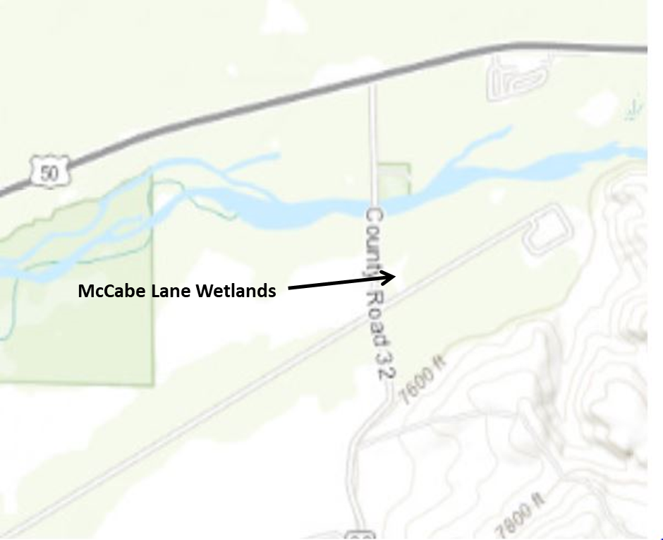
McCabe Lane Wetlands, Gunnison County
Managed by: City of Gunnison
Location: 4.5 miles west of Gunnison
Directions: From Gunnsion, take US Highway 50 4.5 miles west towards Blue Mesa Reservoir. Watch for a left turn lane for County Road 32 and a sign for Riverway river access. Drive south approximately ¾ of a mile, passing over the Gunnison River and take the first left turn into a gravel parking area with a hand-painted McCabe Lane Wetlands sign. Coming from Montrose, look for the Riverway sign approximately 2 miles past the Neversink Day Use Area of the Curecanti National Recreation Area.
Accessibility: Access to the area is free. A dirt path leads to the east toward an old metal building before it diverges into a couple of dirt paths leading to several ponds and the riparian area bordering the Gunnison River. Although level ground, the narrow trails are not handicap accessible, and there are no restrooms at the site.
Habitat: Starting in a weedy meadow, most of the area consists of several willow and/or cattail-lined ponds, one of them being several acres in size. A short portion of one of the trails briefly enters a cottonwood-dominated riparian area.
Birds you might see: As expected, these wetlands attract a variety of ducks and other wetland-associated birds, such as tree and violet-green swallows, marsh wrens, red-winged blackbirds, McGillivray’s, yellow, and Wilson’s warblers, and great blue herons. Bald eagles, red-tailed hawks, and Swainson’s hawk’s (in summer) are often seen flying over the area. Sparrows are common, including chipping, song, and Lincoln’s in summer and white-crowned and American tree sparrows in late fall. Over 170 species have been reported at this location according to eBird.
Best time of the year: Fall and spring are the best time to visit in order to see the largest number of ducks and other wetland species. Summer can also be productive.
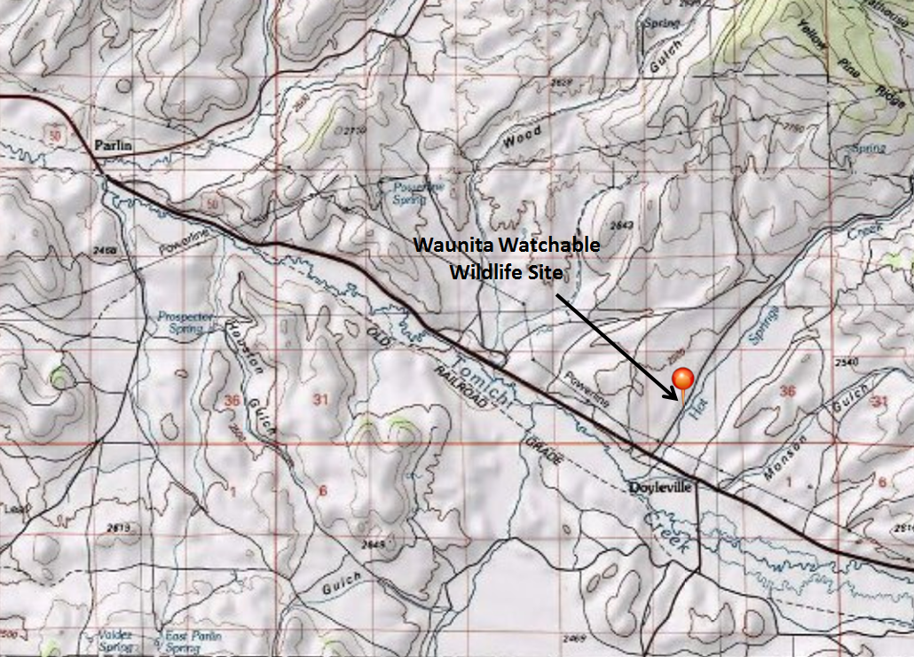
Waunita Watchable Wildlife Site, Gunnison County
Managed by: Colorado Parks and Wildlife
Location: 19 miles east of Gunnison, ½ mile north from highway 50
Directions: From Gunnison, take Highway 50 east for 19 miles and turn north (left) onto County Road 887 towards Waunita Hot Springs. Go 0.6 miles to a small pull-off on the right, where you can sit in your car to view birds.
Accessibility: County road is gravel, so site is accessible to all cars. However, accessibility is somewhat limited by space due to a short lekking season. To ensure that you can view the lek, show up well before the required arrival time (one hour before sunrise). Check the schedule before going to be sure you are not visiting on a day that is closed to the public (in an effort to reduce impacts to the birds). Accessible to all cars, no entrance fee required. However, if you would like to use the private viewing blind, contact Sisk-A-Dee (see website below). Additionally, visitors are encouraged to purchase Habitat Stamps from Colorado Parks and Wildlife to support wildlife viewing opportunities across the state, like this!
Habitat type: Sagebrush and irrigated meadow
Birds you might see: Gunnison Sage-Grouse! This is the only public viewing site in the world to see these birds. In addition, you may see a variety of sagebrush songbirds, red-winged blackbirds, Wilson’s snipe, corvids and raptors.
Best time of year: April 1 to May 10, visitors MUST arrive at least one hour before sunrise
More information: http://www.siskadee.org/view.htm - please visit this website before visiting Waunita, as it provides very important information on the viewing protocol. These guidelines were established to ensure that visitors follow ethical guidelines to minimize disturbance to the birds.
Montrose County
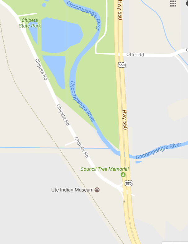
Chipeta Lake, Montrose
Management: City of Montrose (formerly Colorado Parks and Wildlife).
Location: Approximately three miles south of downtown Montrose.
Directions: Follow Colorado Highway 550 south out of Montrose. After passing the Target Shopping Center, stay in right hand lane. Turn right with exit lane onto Chipeta Road. You will cross over the Uncompaghre River bridge before making turn. The Ute Indian Museum is on the immediate left. Continue north on Chipeta Road less than one mile. The lake is on the right side of road, with several dirt pull-outs; there is heavy traffic on Chipeta Road, so be careful pulling on and off. A parking area is on the northern end of the lake, accessed from Chipeta Road by Old Chipeta Trail.
Accessibility: The dirt pull offs are mostly flat. These offer the best view points of lake. If you choose to go around the lake, you must descend a flight of stairs or drive around to the parking area on the northern side. A dirt trail can be followed around lake, which also provides access to the Uncompahgre River.
Habitat type: A small lake with a spillway dam and some “improvements.” It is stocked with trout each spring. The roadside pull-outs have tall bushes blocking much of the view, but there are several good openings between them. If you remain in your vehicle, birds on the water are less likely to be spooked. The lake is heavily used by people fishing, spring through fall, with an occasional small water-craft. The lake usually freezes over in winter during cold snaps, but sometimes the southern end remains open and is a good place to see waterfowl and bald eagles.
Birds you might see: One of the better birding spots in the Uncompaghre Valley. Numerous duck species can be seen fall through spring and during winter when lake is not frozen. A variety of song birds can be found in the shrubs and trees during migration and summer. In winter look for bald eagles. Osprey, kingfishers, and a vagrant cormorant have been seen here. Chipeta Lake is an eBird hotspot with over 60 species recorded.
More Information: http://cpw.state.co.us/swa/Chipeta%20Lake%20SWA
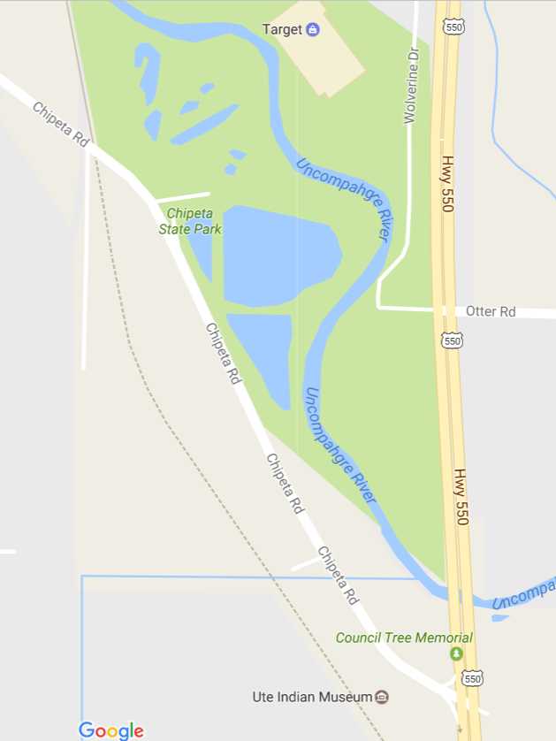
Ute Indian Museum Grounds and Native Garden, Montrose
Management: History Colorado, a division of the Colorado State Government.
Location: Approximately three miles south of downtown Montrose.
Directions: Follow Colorado Highway 550 south out of Montrose. After passing the Target Shopping Center, stay in the right-hand lane. Follow the turn lane onto Chipeta Road. The Museum is on the immediate left and is well worth visiting. The museum has extensive tree-covered grounds on the west side of the road and a native garden on the east side of the road with access to the Uncompaghre River.
Accessibility: Ample parking is in front of the museum with handicap parking spaces. The museum grounds to the north of the museum are fairly level, with an extensive grassy lawn and sandy-gravel walking paths. Use the crosswalk to access the native garden on the eastern side of Chipeta Road; watch for fast, heavy traffic at times. A flight of stairs descends into the garden. The garden can also be accessed from a small parking lot at the north end where stairs are not needed but the trail is not flat and may not meet ADA standards. Note: The trails in the garden area are graveled. A wooden bridge with steps on each side and a boardwalk with steps lead into a wetlands area along the Uncompahgre River.
Habitat: The grounds of the museum are like a city park with large expanses of grass and mature deciduous and coniferous trees. The garden area across the street has a collection of native and non-native flowers, shrubs, and trees. On the eastern edge of the garden is a row of very large Siberian elm trees. A small stream and pond are in the garden. A boardwalk and numerous wooden stairs at the north end of the garden will take you down to the flood plain of the Uncompahgre River with an extensive cattail marsh. There are viewing platforms and benches.
Birds you might see: The variety of habitat plus the small riparian area attracts numerous song birds through migration and the summer months into early September. Birds such as swallows, goldfinches, siskins, hummingbirds, warblers, waxwings, and a variety of birds of prey can be seen. The museum is an eBird hotspot with over 50 species recorded.
Best time of year to visit: Spring and summer.
More information: http://www.historycolorado.org/museums/ute-indian-museum-0
Comments: Chipeta, the famous wife of the Ute Chief Ouray, is entombed on the grounds. A natural spring, now found inside a concrete tipi, was used by the Dominguez and Escalante Expedition in 1776. The spring was used extensively by the Ute People for centuries and is still used today by modern Utes. The museum grounds are held in reverence by today’s Utes. Please be respectful of this historically significant site.
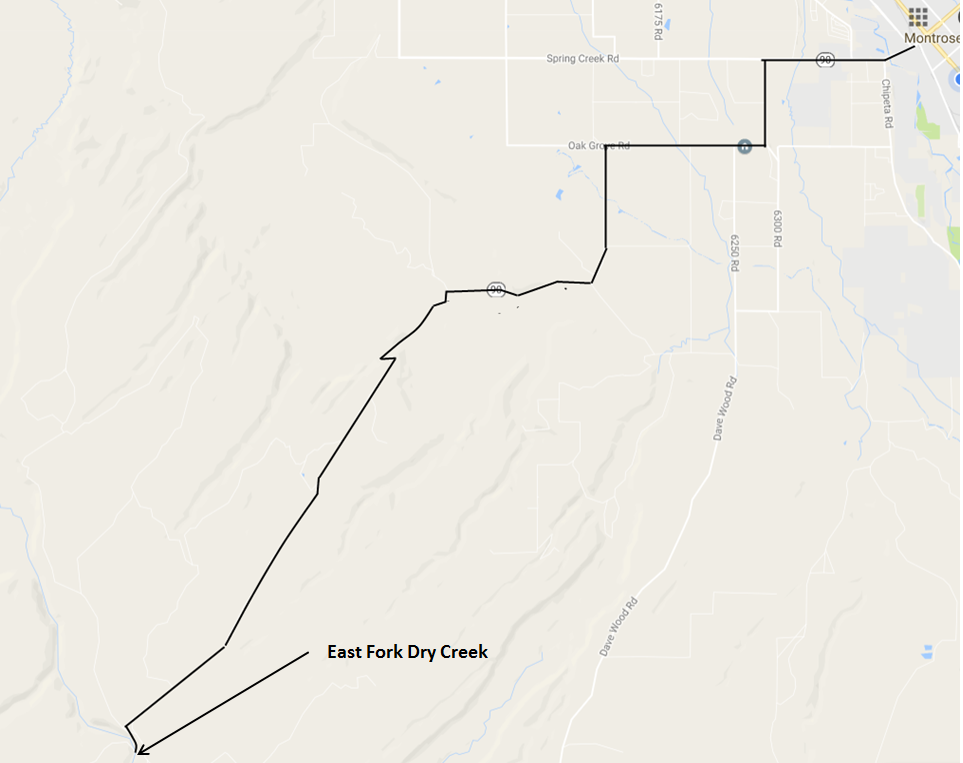
East Fork of Dry Creek, Uncompahgre Plateau, Montrose County
Management: Bureau of Land Management, Uncompahgre Field Office.
Location: The area is about 15 miles southwest of Montrose at the crossing of the East Fork of Dry Creek by Highway 90 on the Uncompahgre Plateau.
Directions: From the intersection of Main St. and Townsend Ave. in Montrose, take West Main St. westward for 2 miles, keeping right at the intersection with Chipeta Road where Main St. transitions to Highway 90, and turn left at the top of the hill where Highway 90 begins its zigzag route across Spring Creek Mesa. After 4.5 miles of multiple turns across the mesa, Highway 90 enters Shavano Valley. Continue westward about 1.4 miles along and across Shavano Valley, continuing on Highway 90 to the left past the intersection from the south of Shavano Valley Road, whereupon the pavement ends and the road begins to climb onto the Uncompahgre Plateau. Continue westward on Highway 90 for about 6.8 miles to the edge of the canyon of Dry Creek. Continue about 0.3 miles to the bottom of the canyon and cross the East Fork of Dry Creek and park on the left side of the road. Birding is best from the parking area southward and from highway 90 to the north, looking down into the shrubs and trees along the creek.
Accessibility: The parking area and informal trails to the south access excellent habitat and walking the shoulder of Highway 90 above the creek to the north provides excellent viewing. There is not much traffic, but beware of vehicles on the road. Informal trails penetrate the vegetation short distances southward from the parking area.
Habitat type: The creek provides dense riparian habitat of willows, aspen, and cottonwoods with tall conifers on the margins. Pinyon-juniper forest covers the surrounding area.
Birds you might see: A wide variety of passerines are present, including warblers (Virginia’s, yellow, and yellow-rumped), flycatchers (western wood-pewee, olive-sided), nuthatches, hermit thrush, house wren, warbling vireo, ruby-crowned kinglet, mountain chickadee, chipping sparrow, violet-green swallow, house wren, and juncos. Woodpeckers (northern flicker, red-naped and Williamson’s sapsucker), broad-tailed hummingbird, and hermit thrush are possible. A band-tailed pigeon was seen flying through the area a few years ago.
Best time of year to visit: Spring and summer to catch migrants and nesting birds.
More information: Areas farther west on Highway 90 include Silesca Pond, where a sora is sometimes present, and Buck Trail, where three-toed woodpeckers have been seen. Look for clearings in the woods along the road for bird activity with a wide variety of birds possible, including nuthatches, western bluebirds, crossbills, flycatchers, and others.
Comments: There are no facilities and the location is not marked, though it is readily recognizable, being at the bottom of the canyon with an ample, though informal, parking area. Highway 90 is closed during the winter; do not attempt to travel the road during closure.
Ouray County
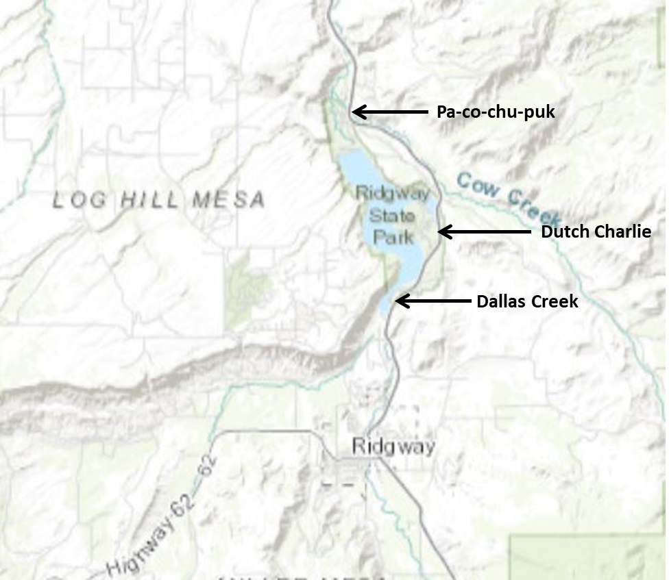
Ridgway State Park, Ouray County
Managed by: Colorado Parks and Wildlife / Bureau of Reclamation
Location: 2 miles north of Ridgway at Ridgway Reservoir
Directions: From Montrose, travel 17 miles south on US Highway 550 towards Ouray. The Park has three entrances, Pa-co-chu-puk on the northern end, Dutch Charlie in the middle, and Dallas Creek at the southern end. If this is your first visit, the Visitor Center is near the Dutch Charlie Entrance.
Accessibility: An entrance fee (currently $9) is collected year-round. Either pay at entrance station or purchase or possess a current Colorado State Parks Pass. The parking lots are paved and public toilets are available.
Habitat: Accessing the park via the Pa-co-chu-puk entrance allows you access to the Uncompahgre River below the dam. In addition to several campgrounds (both RV and walk-in tenting) there is nice riparian habitat, several fishing ponds, rocky cliffs, a small Ponderosa Pine stand, mixed sagebrush savannah and pinon-juniper woodlands.
The Dutch Charlie entrance starts in a mix of dry sagebrush grassland and mature pinon-juniper woodlands. A lookout near the visitor center offers a sweeping view of the reservoir and the beautiful San Juan Mountains to the south. This section of the park also includes a boat marina and a small but good mud flat (at lower water levels) at the upper end of Mears Bay.
The Dallas Creek section includes sagebrush flats, pinyon-juniper-covered hillsides with exposed cliffs and good riparian habitat at the southern end of the park. It also includes a large section of exposed lakeshore at the Bay View Day Use Area as the reservoir water levels drop in late summer.
Birds you might see: Due to the variety of habitats and the large size of the reservoir, Ridgway State Park is the premier birding spot in Ouray County currently having a total of 235+ species recorded in global eBird database. The family corvidae is well represented (common raven, American crow, Steller’s jay, pinyon jay, Clark’s nutcrackers, black-billed Magpies, and occasional Canada Jays), as are raptors and ducks along with other water birds.
The Pa-co-chu-puk section is good for songbirds including a variety of warblers (yellow, Wilson’s yellow-rumped, Virginia’s, black-throated gray, MacGillivray’s), raptors (osprey, red-tailed hawk, bald and golden eagles), corvids, woodpeckers, and thrushes (American robin, Townsend’s solitaires, hermit thrush, mountain and western bluebirds).
The Dutch Charlie section is good for pinyon-juniper birds including all of the corvids listed earlier, plumbeous vireos, bluebirds, finches and goldfinches, sparrows (chipping, vesper, Brewer’s), and bluebirds. Near the reservoir ducks, grebes, shorebirds and gulls are commonly seen. Don’t forget to check out the reservoir from the overlook near the visitor center, especially if you have a spotting scope.
The Dallas Creek entrance provides access to the southern end of the lake where the Uncompahgre River enters the reservoir. The Bay View Day Use area is the point where you can access the exposed shoreline of the lake. This area is the best location for viewing the ducks, grebes, loons, gulls, and shorebirds that visit the reservoir in the spring and fall. Over 155 species have been recorded here. Moving further south in the park, Dallas Creek Day Use Area has a very nice riparian area, particularly along Dallas Creek upstream from where it joins the river. Yellow warblers, gray catbirds, house wrens, and song sparrows are common summer breeders. A banding station is set up here each fall, and it has produced some surprising finds including golden-winged warbler, hooded warbler, and yellow-breasted chat. Raptors such as northern pygmy-owl, golden and bald eagles, osprey, Cooper’s hawk, red-tailed hawk, American kestrel, and peregrine falcon are regularly seen in the area.
Best time of the year: Birding is best during migration, but birds are present year-round. Recreational use of the reservoir is quite heavy in the summer, so focus on the areas with less disturbance and try to arrive early or late in the day.
Additional information: http://cpw.state.co.us/placestogo/parks/Ridgway
eBird Hotspots:
Entire Park
Ridgway Reservoir & SP, Ouray, US-CO
Paco-chu-puk Entrance:
Ridgway Reservoir--below the dam, Ouray, US-CO
Dutch Charlie Entrance:
Ridgway SP--Visitor Center & campgrounds, Ouray, US-CO
Ridgway SP--Marina area, Ouray, US-CO
Dallas Creek Entrance:
Ridgway SP--Bay View Day Use Area, Ouray, US-CO
Ridgway SP--Dallas Creek area, Ouray, US-CO
Great Blue Heron or Sandhill Crane?
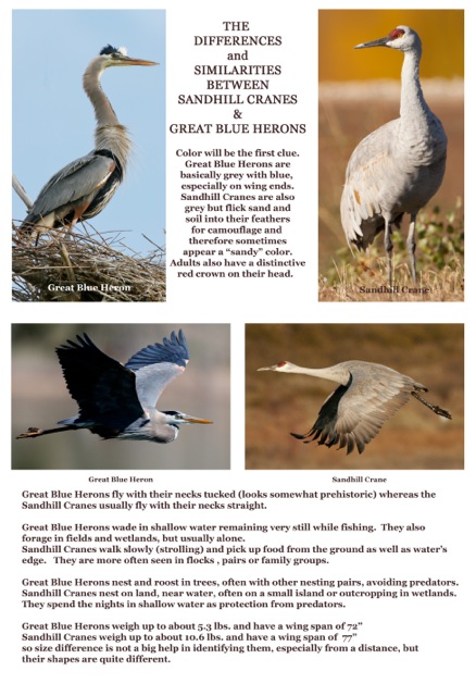
Information and photographs provided by Carole Scott